Eastern US in crosshairs for another major storm
by Alex SosnowskiA stormy weather pattern has evolved in the eastern United States during the second week of December, and forecasters say it's likely to culminate in a significant weather system later this week.
Despite a blast of Arctic air and an episode of wintry precipitation at midweek, temperatures are forecast to quickly rebound ahead of the next major storm in most but not all areas of the East Friday and Saturday.
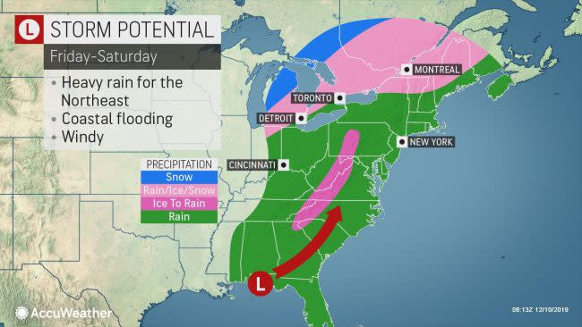
AccuWeather meteorologists expect a narrow zone of heavy snow to develop on the back side of the storm, but most areas can expect a dose of rain rather than snow over the eastern third of the nation.

Instead of an intense storm traveling up the spine of the Appalachians or hugging the coast with cold air nearby and heavy snow in the eastern part of the Ohio Valley, a more moderate storm will travel in the swath between the Appalachians and the Atlantic coast during Friday and Saturday.
Enough cold air will remain rooted in parts of the East to allow for some wintry precipitation and travel.
Some snow is forecast to fall on the central Great Lakes with a wintry mix for a time in northern New England. However, a more dangerous form of precipitation is forecast for a narrow zone across the interior, including parts of the South.
A shallow wedge of cold air is likely to linger long enough in the lower part of the atmosphere to allow freezing rain from upstate South Carolina to western North Carolina, northwestern Virginia, eastern West Virginia and parts of western and central Pennsylvania. Timing and duration of this ice event is key as to the severity of impact.
"Since the freezing rain is probably going to begin later Thursday night and last for several hours over the Carolina and southern Virginia Piedmont, these areas stand the greatest risk of a significant buildup of ice," AccuWeather Senior Meteorologist Eric Leister said.

"These same locations may have ice accrue to a thickness of 0.10 to 0.25 of an inch," Leister added.
At this thickness, there may be enough ice to weigh down some tree limbs to the point where they break and potentially bring down power lines.
"Farther north, the freezing rain is likely to hold off until the daylight hours on Friday or early Friday evening," Leister said.
At the same time, warmer air will be surging in aloft and will limit the duration and buildup of ice.
"Because the air aloft will be constantly warming during the storm, the duration of ice is likely to much shorter across Pennsylvania as opposed to North Carolina," Leister explained.
Even a thin coating of ice can be extremely dangerous for motorists and pedestrians. Black ice could be a major threat to motorists along much of the Interstate 81 corridor from northeastern Tennessee to south-central Pennsylvania. Portions of I-40, I-64, I-66, I-68, I-70, I-77, I-77, I-80 and I-99 will be within the zone of potential ice as well.
Rain from the storm will be nothing short of drenching in most areas. On the order of 1-2 inches with locally higher amounts will fall in 6-18 hours. An AccuWeather StormMax™ of 3 inches is forecast. At this rate, the rain can be heavy enough to cause street flooding.
Flooding along small streams and some rivers is also a concern with this late-week storm as the drenching rain will follow only a few days after a soaking from the storm at the start of the week. This is especially possible where the snow cover was wiped out or greatly reduced by the early-week storm from northern Pennsylvania to central Maine.

The same storm will also soak part of the Deep South, where abnormally dry to moderate drought conditions have persisted in recent weeks.
A much lower amount of rain is likely over the central and southern part of the Florida Peninsula, compared to much of the Eastern states with the storm. It is possible that the zone from Naples to Miami and Fort Lauderdale barely gets a brief shower from Friday to Saturday.
Download the free AccuWeather app to check the forecast in your area. Keep checking back on AccuWeather.com and stay tuned to the AccuWeather Network on DirecTV, Frontier and Verizon Fios.